CASE STUDY
sCHoolmap: Enhancing Geographic Literacy and Real-Life Learning through Interactive Mapping in Swiss Schools
Sector : Location-Based Services, National Mapping I Geography : Europe I Country : Switzerland
Case Study
sCHoolmap: Enhancing Geographic Literacy and Real-Life Learning through Interactive Mapping in Swiss Schools
sCHoolmap: Enhancing Geographic Literacy and Real-Life Learning through Interactive Mapping in Swiss Schools
Source: EuroGeographics
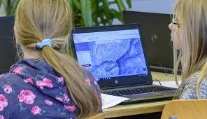
The sCHoolmap platform, developed by swisstopo in collaboration with other Swiss federal offices, is an innovative educational tool that integrates digital mapping into school curricula. Hosted via geo.admin.ch, the platform provides interactive maps and a wide array of teaching resources designed for pupils from primary to secondary levels. It builds on the official federal map viewer that enable students to explore real-world geography. Pupils can measure distances, calculate elevation differences, annotate maps, and apply spatial reasoning to everyday examples, such as planning routes or understanding local land use. The initiative bridges geography education with practical digital literacy, reaching more than half of Swiss schools and making map-based learning accessible, engaging, and free of charge.

Federal Office of Topography swisstopo
