CASE STUDY
Leveraging LiDAR Imaging for Pueblo Preservation and Unlocking Ancient Mysteries
Sector : Natural Resources and Environment I Geography : North America/Central America/Caribbean I Country : USA
Case Study
Leveraging LiDAR Imaging for Pueblo Preservation and Unlocking Ancient Mysteries
Leveraging LiDAR Imaging for Pueblo Preservation and Unlocking Ancient Mysteries
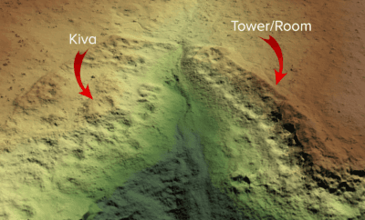
Source: LIDAR Magazine
Traditional mapping proved insufficient for Sand Canyon, an ancestral Pueblo site, prompting the use of UAV LiDAR technology by the Crow Canyon Archaeology Center and Canyons of the Ancients National Monument. This approach, led by Routescene Inc. and Caddis Aerial, yielded new insights and remarkable outcomes. Their collaboration produced a high-resolution terrain model, overcoming dense vegetation for comprehensive data collection.

Crow Canyon Archaeological Center; Bureau of Land Mangement, U.S. Department of the Interior

Routescene; Caddis Aerial