Human Rights Advocacy with Geospatial Intelligence
Source: American Association for The Advancement of Science
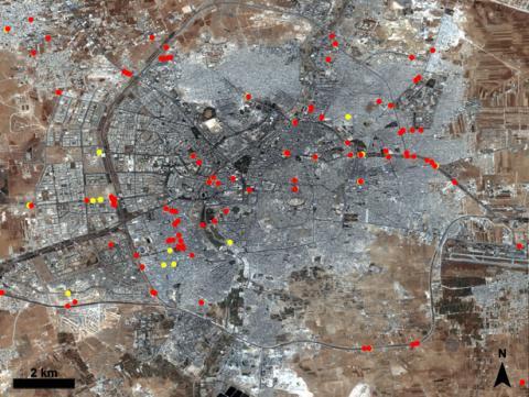
Collaborating with Maxar Technologies, the American Association for the Advancement of Science (AAAS) spearheaded a project employing satellite imagery and remote sensing analysis to meticulously monitor and document human rights violations in conflict zones and restricted areas. By impartially capturing evidence of atrocities, including land destruction, population displacement, and infrastructure damage, the initiative bolsters advocacy efforts, fortifies legal proceedings, and advocates for accountability against perpetrators of violence.
In concert with advocacy groups, international agencies, and governmental bodies such as USAID and the Department of State, this project underscores the indispensable role of geospatial technologies in championing justice, fostering peace, and upholding human rights globally.

AMERICAN ASSOCIATION FOR THE ADVANCEMENT OF SCIENCE

Maxar Technologies; Zimbabwe Lawyers for Human Rights (ZLHR); United States Agency for International Development