CASE STUDY
Harnessing Geospatial Technologies for Sustainable Urban Development: A Case Study of Waterford City
Sector : Natural Resources and Environment I Geography : Europe I Country : Ireland
Case Study
Harnessing Geospatial Technologies for Sustainable Urban Development: A Case Study of Waterford City
Harnessing Geospatial Technologies for Sustainable Urban Development: A Case Study of Waterford City
Source: Waterford City and County Council
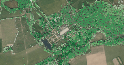
Waterford City and County Council leads Ireland's drive for environmental sustainability and climate resilience by aiming to become the nation's first decarbonized city by 2030. Central to this effort is the strategic use of geospatial technologies, particularly the Bluesky National Tree Map™ (NTM™), to map and optimize the city's green infrastructure. Waterford Council, in collaboration with Bluesky International Ltd., leverages geospatial insights to drive its carbon neutrality agenda, exemplifying the vital role of technology in shaping a sustainable urban environment. Through innovative approaches and data-driven decision-making, Waterford seeks to enhance its urban forest cover, mitigate carbon emissions, and align policies with sustainable development goals (SDGs).

Waterford City and County Council

Bluesky International Ltd
