CASE STUDY
Building a Trusted Data Framework for the National Underground Asset Register (NUAR)
Sector : National Mapping I Geography : Europe I Country : UK
Case Study
Building a Trusted Data Framework for the National Underground Asset Register (NUAR)
Building a Trusted Data Framework for the National Underground Asset Register (NUAR)
Source: AtkinsRéalis
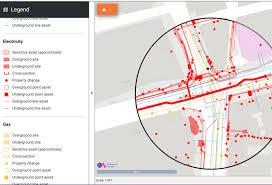
The National Underground Asset Register (NUAR) pilot, led by Ordnance Survey (OS) in partnership with the Geospatial Commission and the Greater London Authority, aimed to demonstrate the feasibility of a unified, trusted data-sharing platform for underground utilities. The initiative addressed the long-standing challenge of fragmented, privately held underground infrastructure data in the UK, which often leads to costly and dangerous excavation incidents. Through the creation of a communal register prototype, the project successfully integrated asset data from multiple competing utility providers and local authorities in Northeast England. By providing a single, accurate and secure view of buried assets, accessible on mobile devices and field equipment, the platform improved operational efficiency, worker safety, and data-driven planning for construction and emergency response operations.

Ordnance Survey Limited

Greater London Authority; Geospatial Commission, Part of Department for Science, Innovation and Technology